Meteorology

Weather systems, forecasts, METAR/TAF, and aviation weather services.

17
Free Questions
97
Premium Questions
Oct 3, 2026
Last updated

Questions and model answers

25 questions on this page

General 4 questions
Why can icing be hazardous before a large accumulation is visible? Answer available

Small deposits can disrupt airflow, reduce lift and increase drag. Use the approved icing procedures and limitations rather than judging safety only by visible thickness.

How does radiation fog form? Answer available

The ground cools through radiation and chills moist air near the surface to saturation. Clear skies and light winds often favor its development.

Why is a microburst dangerous on approach? Premium answer
This model answer is included with Premium access.

Compare the access plans to open the complete answer library for your selected period.

Compare access plans
Can severe turbulence occur outside cloud? Premium answer
This model answer is included with Premium access.

Compare the access plans to open the complete answer library for your selected period.

Compare access plans
General Meteorology 6 questions
How does pressure affect an aircraft’s altitude? Answer available

The altimeter measures altitude relative to a reference pressure (usually QNH). If the altimeter is not set correctly, it can give a misleading altitude reading.

  • If the altimeter setting is lower than the actual QNH → the altimeter underreads, and the aircraft is higher than indicated
  • If the altimeter setting is higher than the actual QNH → the altimeter overreads, and the aircraft is lower than indicated

This is summarized by the phrase:
"From high to low, look out below"

Why?
With QNH set on the altimeter, the instrument indicates altitude above mean sea level. But since air pressure decreases with height, a mismatch between actual and set QNH shifts the reference level.

Example:
If you set QNH 1025 while the actual QNH is 1005, you're referencing a higher pressure level. The difference is 20 hPa →
20 × 27 ft = 540 ft

Your altimeter will read 540 ft higher than your true altitude.
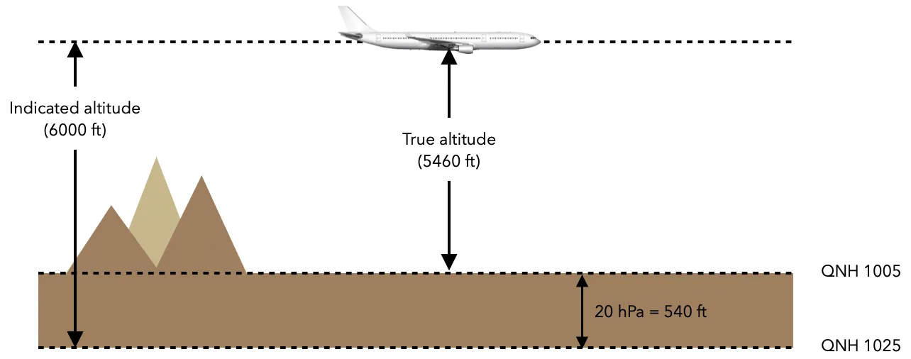
Wrong Qnh diagram

So, setting a QNH higher than the actual value leads to altimeter overread and puts the aircraft lower than indicated — a potentially hazardous situation near terrain or obstacles.
Define radiation fog. Answer available

Radiation fog forms overnight when the ground loses heat through radiation, causing the air near the surface to cool down to its dew point.

As the air reaches saturation, fog develops near the ground. This type of fog typically forms under the following conditions:
- Clear skies, allowing maximum radiative cooling
- Light winds, which prevent mixing and help the fog remain in place
- Moist surface air close to saturation

Radiation fog occurs only over land, and is most common during autumn and winter, when nights are longer and surface cooling is more pronounced.

After sunrise, the ground warms, increasing the temperature–dew point spread, and the fog gradually dissipates.

What is the difference between QNH and QFF? Answer available

QNH and QFF are both pressure values reduced to mean sea level (MSL), but they differ in how the reduction is calculated and in their purpose:

QNH

  • Used in aviation as the standard altimeter setting to display altitude above MSL.
  • Calculated from the actual station pressure, assuming standard atmospheric conditions (ISA) between the station and sea level.
  • Provided in ATIS, METAR, and by ATC.
  • Used by pilots to set their altimeters during approach, landing, and take-off phases.

QFF

  • Used mainly in meteorology, not for operational flying.
  • Also reduced to sea level but uses the actual temperature and humidity conditions at the time of observation.
  • Provides a more accurate representation of the true surface pressure at sea level for weather analysis.
  • Not used as an altimeter setting.

In summary:
- QNH is used by pilots to set altimeters and fly at correct altitudes.
- QFF is used by meteorologists to build surface pressure charts.

How does a microburst affect an aircraft during flight? Answer available

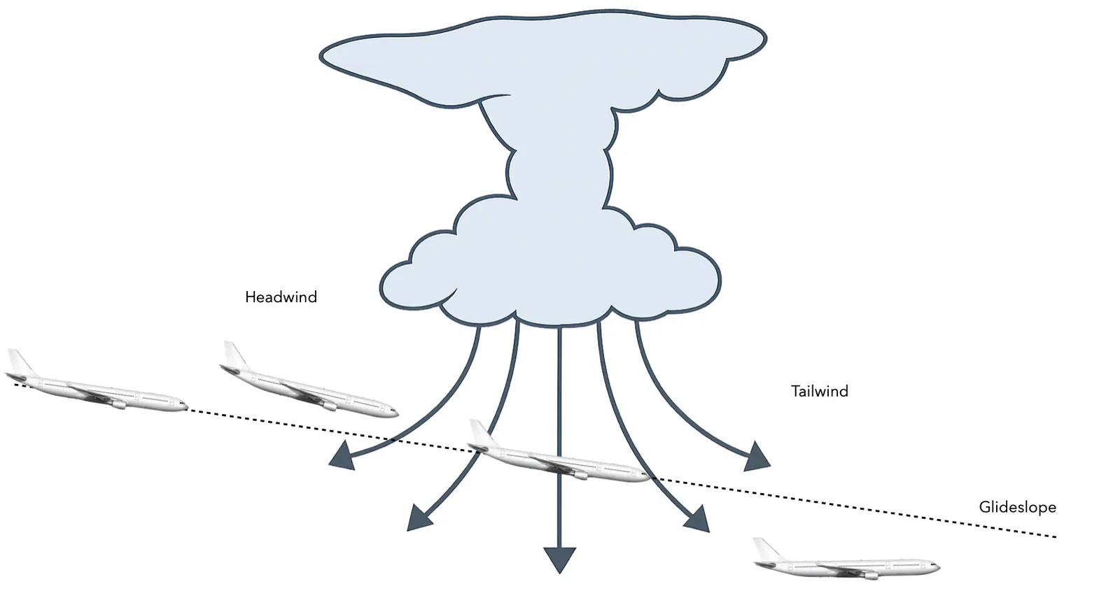
A microburst is a strong, localized downdraft associated with thunderstorms, often occurring during convective activity. When the descending air hits the ground, it spreads horizontally in all directions, creating intense and rapidly changing wind conditions.

Effect on aircraft performance:

  1. Entering the microburst →
    - Aircraft encounters a strong headwind
    - Airspeed increases, rate of descent decreases

  2. Entering the downdraft zone →
    - Headwind component decreases
    - Airspeed drops, aircraft begins to descend rapidly

  3. Exiting into the tailwind →
    - Aircraft encounters a strong tailwind
    - Further reduction in airspeed and increased sink rate

Microburst diagram

Note: Microbursts can exceed the aircraft’s performance capabilities, especially at low altitude, and must be strictly avoided.
They typically have a diameter of less than 4 km and last less than 5 minutes, but can be extremely hazardous during takeoff or landing.

What is the relationship between temperature, pressure and density? Premium answer
This model answer is included with Premium access.

Compare the access plans to open the complete answer library for your selected period.

Compare access plans
Which wind source should be used to calculate takeoff performance: METAR or ATIS? Premium answer
This model answer is included with Premium access.

Compare the access plans to open the complete answer library for your selected period.

Compare access plans
Cold-soaked surfaces 1 question
Can ice form on an aircraft after landing when the reported outside air temperature is above zero? Answer available

Yes. Aircraft skin and fuel do not instantly reach the temperature of warmer surrounding air. A cold-soaked surface can remain below freezing after descent and landing, especially around some fuel-tank areas. Moisture contacting that surface can freeze even though the reported air temperature is positive. The relevant physical condition is the surface temperature, not the airport thermometer alone. Apply the aircraft’s contamination inspection and ground-icing procedures; a positive temperature report is not sufficient evidence that the wing is clean.

Scope: General aviation meteorology; apply aircraft-specific procedures.

Sources

Datalink latency 1 question
A NEXRAD mosaic is marked one minute old. Does that mean the weather shown was observed one minute ago? Answer available

No. The age label can describe when the provider created the mosaic, rather than when every contributing radar observed the weather. Scanning, transmission and assembly add delay, and a refreshed mosaic may still contain older data from some sites. NTSB SA-017 documents extreme cases in which the oldest observations can be 15–20 minutes older than the displayed age. Use the product with that limitation in mind; an apparently fresh image cannot establish the present position of a rapidly developing cell.

Scope: General aviation meteorology; apply aircraft-specific procedures.

Sources

Dry downburst cues 1 question
What makes virga and a spreading dust plume a concerning combination near an approach path? Answer available

Virga is precipitation that evaporates before reaching the ground. Evaporation cools the surrounding air and can strengthen a descending current. If that current reaches the surface and spreads outward, it may raise a dust plume or dust foot while little rain reaches the runway. This is a visual cue consistent with a dry downburst, not proof of benign conditions because the surface is dry. Treat the observation as relevant windshear information and apply the approved avoidance decision process.

Scope: General aviation meteorology; apply aircraft-specific procedures.

Sources

Freezing drizzle escape assumptions 1 question
Does encountering freezing drizzle guarantee that climbing will find an above-freezing layer? Answer available

No. Freezing drizzle can form through collision and coalescence of liquid droplets within a cloud whose temperature remains below freezing. It does not require snow to melt in a warmer layer first. Consequently, assuming there must be warm air above can lead to a poor escape decision. Use the actual temperature profile, cloud information, terrain, aircraft capability and approved procedures to select an exit. NASA specifically warns against assuming an above-freezing layer exists merely because freezing drizzle is present.

Scope: General aviation meteorology; apply aircraft-specific procedures.

Sources

Gust fronts 1 question
Why can the wind at an airport change abruptly before a thunderstorm’s rain reaches it? Answer available

A thunderstorm downdraft spreads outward when it reaches the surface. The leading edge of that outflow, the gust front, can move well ahead of the main precipitation. Its arrival can produce a rapid change in wind direction and speed while the runway is still dry. The rain’s location therefore does not define the full wind hazard. During arrival or departure, combine the storm’s broader evolution with current wind reports and warnings, and follow the aircraft and operator’s windshear avoidance criteria.

Scope: General aviation meteorology; apply aircraft-specific procedures.

Sources

Negative PIREPs 1 question
Why is a report of no icing useful when the forecast predicts icing? Answer available

It tells forecasters and other pilots that the expected hazard was not encountered at a particular place, altitude and time. Negative reports help reveal conditions that did not develop or no longer exist and can improve the operational weather picture. They should include enough context to be useful, including aircraft type and the observed altitude or layer. A negative report remains a limited observation: it is not a guarantee for another aircraft, a nearby layer or the same location later.

Scope: General aviation meteorology; apply aircraft-specific procedures.

Sources

Radar tops 1 question
Does climbing above the highest radar return establish that you are above a thunderstorm? Answer available

No. A radar top is the upper limit of a detectable echo, not necessarily the physical cloud top. Liquid water generally decreases with height in a convective cloud, so the upper portion may return little energy while still containing hazardous convection. Airbus explicitly warns that the cloud and its threats can extend well above the detected top. A weak or disappearing echo at altitude therefore cannot, by itself, justify overflying a cell or reducing the required avoidance margin.

Scope: General aviation meteorology; apply aircraft-specific procedures.

Sources

Radiative surface cooling 1 question
How can frost appear on an exposed surface when the official air temperature never fell below freezing? Answer available

The official temperature is measured in air at a specified height, not on every exposed surface. On a clear, calm night, a surface can lose heat by radiation and become colder than the air measurement. If that surface reaches the appropriate subfreezing condition, frost can form locally while the reported temperature remains positive. This is a surface energy-balance effect, distinct from retaining cold fuel after a flight. For aircraft inspection, the actual surface condition matters more than a reassuring temperature alone.

Scope: General aviation meteorology; apply aircraft-specific procedures.

Sources

SLD protection limits 1 question
How can dangerous ice remain on a wing even when its deicing boots are visibly working? Answer available

Supercooled large droplets have enough inertia to strike farther aft than ordinary cloud droplets, sometimes beyond the protected leading edge. Boots can remove ice from their own surface while leaving an accumulating ridge behind them. That ridge can disrupt airflow and handling despite apparently successful boot cycles. The important clue is unusual ice extent, not simply whether the boots inflate. Recognition and exit actions must follow the aircraft’s approved guidance; ordinary icing approval is not evidence of unrestricted capability in every SLD environment.

Scope: General aviation meteorology; apply aircraft-specific procedures.

Sources

Solar flare radio blackout 1 question
How can a solar flare disrupt an aircraft’s HF communications when the local weather is clear? Answer available

Solar X-rays can increase ionization in the lower ionosphere, enhancing the D layer. That changes how HF radio energy propagates and can strongly absorb signals that would otherwise support long-distance communication. The immediate flare-related blackout affects Earth’s sunlit side and is strongest where the Sun is overhead. No local thunderstorm is required. Space-weather information therefore adds a different communication risk to route planning; crews use the communications alternatives and contingency procedures applicable to their operation when service degrades.

Scope: General aviation meteorology; apply aircraft-specific procedures.

Sources

Winds and Turbulence 1 question
Define Foehn wind. Answer available

A Foehn wind is a warm and dry downslope wind that occurs on the leeward (downwind) side of a mountain range, such as the Alps in Europe.

Formation process:

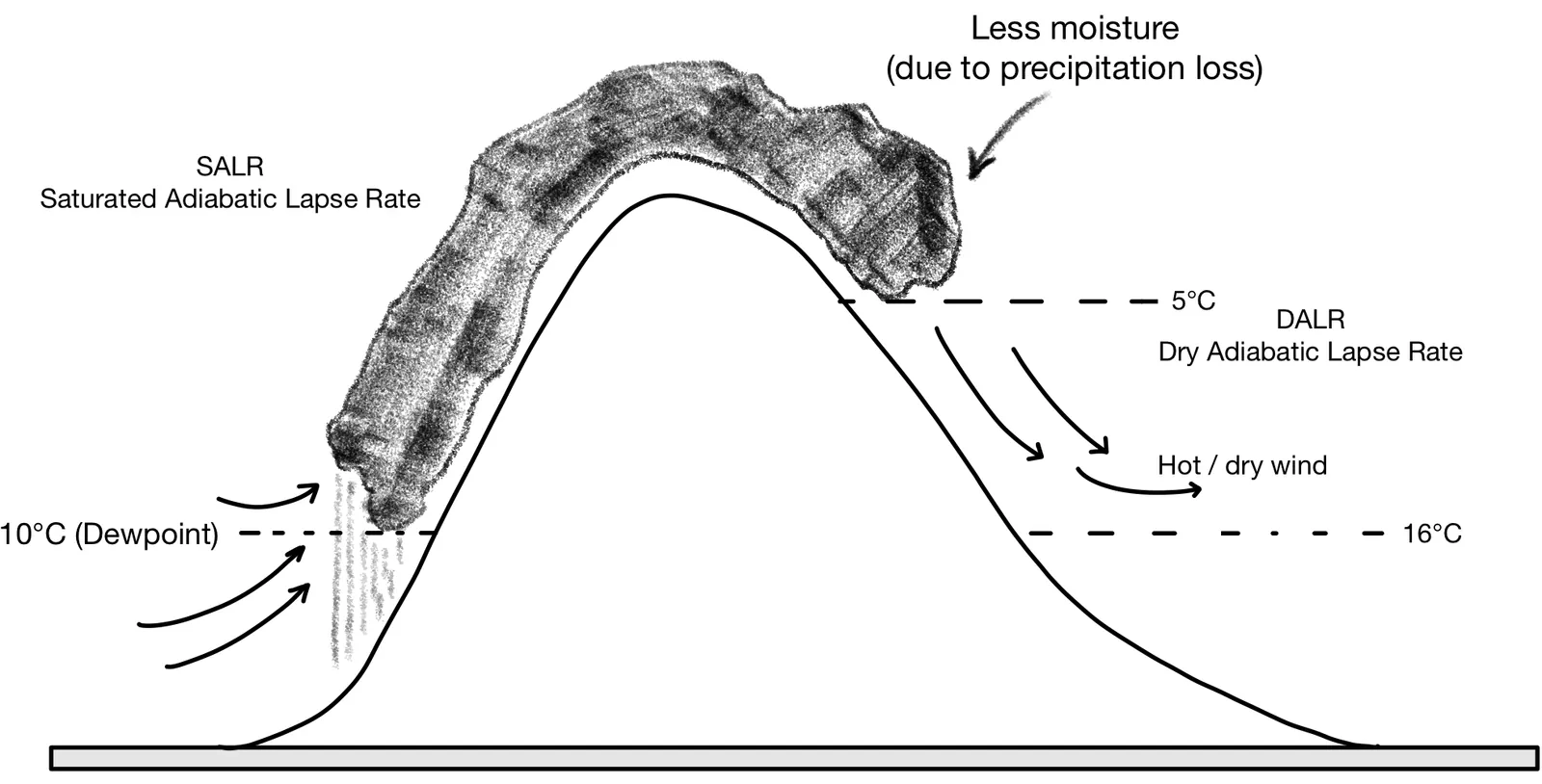
  1. Moist air approaches the mountain and is forced to rise along the windward slope
  2. As the air rises, it cools. Once it reaches its dew point, condensation occurs, forming clouds and causing precipitation
  3. While saturated, the air cools at the Saturated Adiabatic Lapse Rate (SALR) ≈ 1.5 °C / 1000 ft
  4. After losing much of its moisture, the air reaches the mountain crest dry
  5. Descending on the leeward side, it warms up at the Dry Adiabatic Lapse Rate (DALR) ≈ 3 °C / 1000 ft

Because the descending air warms faster than it cooled on the windward side, it arrives at lower altitudes as a warmer, drier air mass.

Result:

  • Windward side: cool, moist air → clouds and precipitation
  • Leeward side: warm, dry air → clear skies and lower humidity

Foehn Effect diagram

Foehn winds can lead to rapid temperature increases, low humidity, and are known to cause turbulence, wave activity, and even psychological effects due to sudden weather shifts.

Anomalous propagation 1 question
How can a weather radar show apparent rain over a dry area during a strong low-level inversion? Premium answer
This model answer is included with Premium access.

Compare the access plans to open the complete answer library for your selected period.

Compare access plans
Composite reflectivity 1 question
Why can a composite radar image show stronger precipitation than the lowest-elevation radar image at the same location? Premium answer
This model answer is included with Premium access.

Compare the access plans to open the complete answer library for your selected period.

Compare access plans
Dual-frequency GPS limitations 1 question
Does using two GPS frequencies make a receiver immune to ionospheric disruption? Premium answer
This model answer is included with Premium access.

Compare the access plans to open the complete answer library for your selected period.

Compare access plans
Equatorial ionospheric scintillation 1 question
Can GPS tracking deteriorate near the magnetic equator after sunset without a major solar storm? Premium answer
This model answer is included with Premium access.

Compare the access plans to open the complete answer library for your selected period.

Compare access plans