How does pressure affect an aircraft’s altitude?
The altimeter measures altitude relative to a reference pressure (usually QNH). If the altimeter is not set correctly, it can give a misleading altitude reading.
- If the altimeter setting is lower than the actual QNH → the altimeter underreads, and the aircraft is higher than indicated
- If the altimeter setting is higher than the actual QNH → the altimeter overreads, and the aircraft is lower than indicated
This is summarized by the phrase:
“From high to low, look out below”
Why?
With QNH set on the altimeter, the instrument indicates altitude above mean sea level. But since air pressure decreases with height, a mismatch between actual and set QNH shifts the reference level.
Example:
If you set QNH 1025 while the actual QNH is 1005, you’re referencing a higher pressure level. The difference is 20 hPa →
20 × 27 ft = 540 ft
Your altimeter will read 540 ft higher than your true altitude.
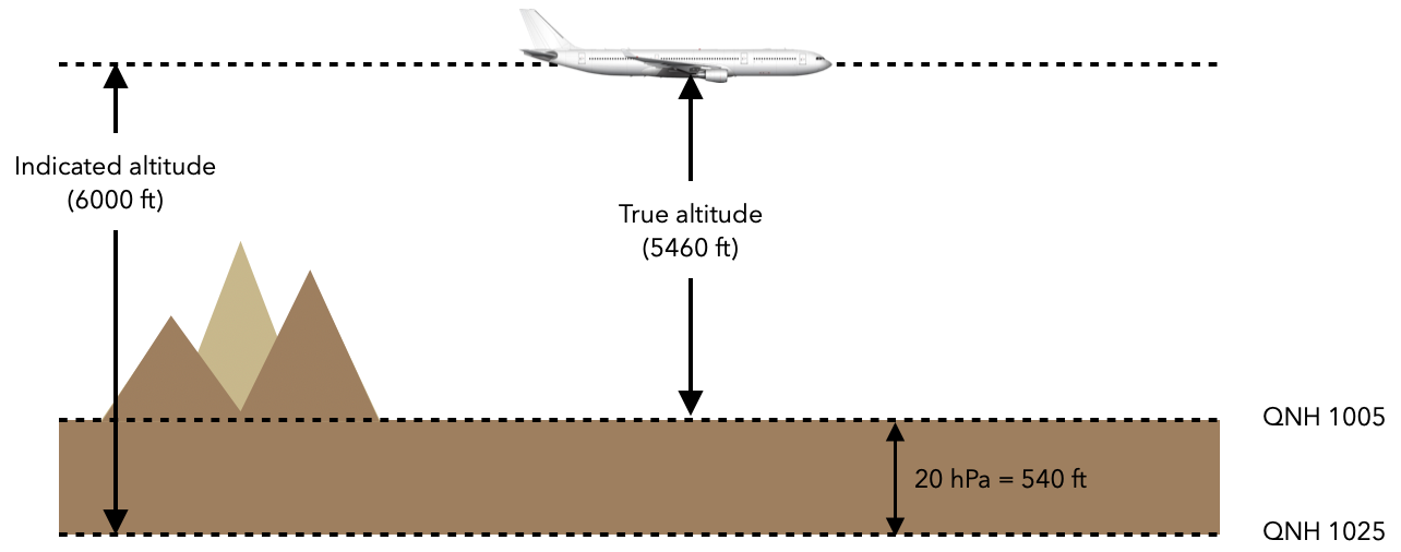
So, setting a QNH higher than the actual value leads to altimeter overread and puts the aircraft lower than indicated — a potentially hazardous situation near terrain or obstacles.
Define radiation fog.
Radiation fog forms overnight when the ground loses heat through radiation, causing the air near the surface to cool down to its dew point.
As the air reaches saturation, fog develops near the ground. This type of fog typically forms under the following conditions:
- Clear skies, allowing maximum radiative cooling
- Light winds, which prevent mixing and help the fog remain in place
- Moist surface air close to saturation
Radiation fog occurs only over land, and is most common during autumn and winter, when nights are longer and surface cooling is more pronounced.
After sunrise, the ground warms, increasing the temperature–dew point spread, and the fog gradually dissipates.
What is the difference between QNH and QFF?
QNH and QFF are both pressure values reduced to mean sea level (MSL), but they differ in how the reduction is calculated and in their purpose:
QNH
- Used in aviation as the standard altimeter setting to display altitude above MSL.
- Calculated from the actual station pressure, assuming standard atmospheric conditions (ISA) between the station and sea level.
- Provided in ATIS, METAR, and by ATC.
- Used by pilots to set their altimeters during approach, landing, and take-off phases.
QFF
- Used mainly in meteorology, not for operational flying.
- Also reduced to sea level but uses the actual temperature and humidity conditions at the time of observation.
- Provides a more accurate representation of the true surface pressure at sea level for weather analysis.
- Not used as an altimeter setting.
In summary:
- QNH is used by pilots to set altimeters and fly at correct altitudes.
- QFF is used by meteorologists to build surface pressure charts.
How does a microburst affect an aircraft during flight?
A microburst is a strong, localized downdraft associated with thunderstorms, often occurring during convective activity. When the descending air hits the ground, it spreads horizontally in all directions, creating intense and rapidly changing wind conditions.
Effect on aircraft performance:
-
Entering the microburst →
- Aircraft encounters a strong headwind
- Airspeed increases, rate of descent decreases
-
Entering the downdraft zone →
- Headwind component decreases
- Airspeed drops, aircraft begins to descend rapidly
-
Exiting into the tailwind →
- Aircraft encounters a strong tailwind
- Further reduction in airspeed and increased sink rate
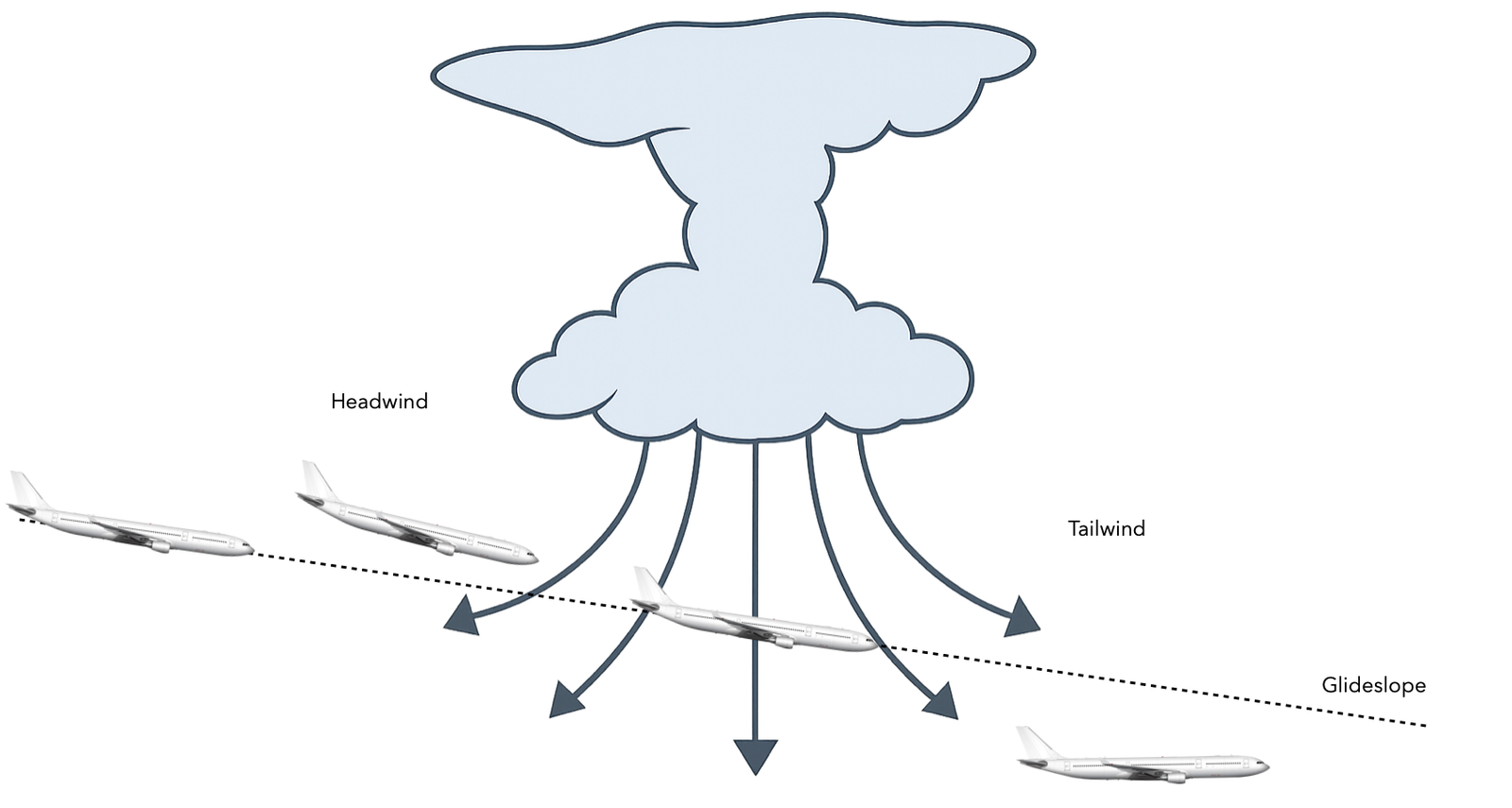
Note: Microbursts can exceed the aircraft’s performance capabilities, especially at low altitude, and must be strictly avoided.
They typically have a diameter of less than 4 km and last less than 5 minutes, but can be extremely hazardous during takeoff or landing.
Define Foehn wind.
A Foehn wind is a warm and dry downslope wind that occurs on the leeward (downwind) side of a mountain range, such as the Alps in Europe.
Formation process:
- Moist air approaches the mountain and is forced to rise along the windward slope
- As the air rises, it cools. Once it reaches its dew point, condensation occurs, forming clouds and causing precipitation
- While saturated, the air cools at the Saturated Adiabatic Lapse Rate (SALR) ≈ 1.5 °C / 1000 ft
- After losing much of its moisture, the air reaches the mountain crest dry
- Descending on the leeward side, it warms up at the Dry Adiabatic Lapse Rate (DALR) ≈ 3 °C / 1000 ft
Because the descending air warms faster than it cooled on the windward side, it arrives at lower altitudes as a warmer, drier air mass.
Result:
- Windward side: cool, moist air → clouds and precipitation
- Leeward side: warm, dry air → clear skies and lower humidity
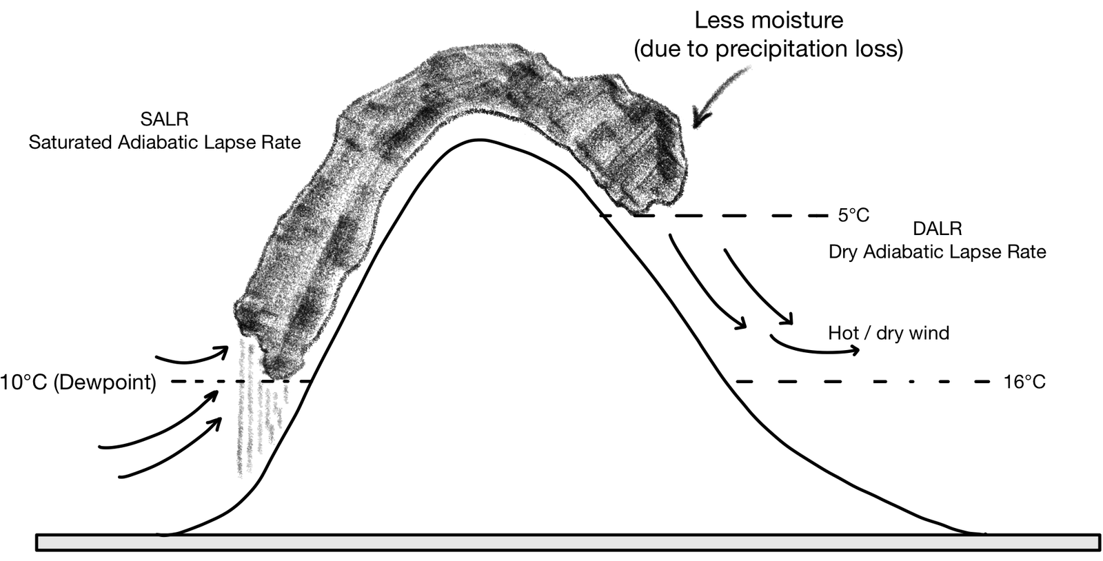
Foehn winds can lead to rapid temperature increases, low humidity, and are known to cause turbulence, wave activity, and even psychological effects due to sudden weather shifts.
Cruise
6.25€/month
- Access to selected Q&A
- All technical questions
- All non-technical questions
- All type-specific questions
- Access exclusive articles
- No automatic renewal
- Access for 12 months
Climb
8.75€/month
- Access to selected Q&A
- All technical questions
- All non-technical questions
- All type-specific questions
- –
- No automatic renewal
- Access for 8 months
Take-off
15€/month
- Access to selected Q&A
- All technical questions
- All non-technical questions
- –
- –
- No automatic renewal
- Access for 4 months
Taxi
20€/month
- Access to selected Q&A
- All technical questions
- All non-technical questions
- –
- –
- No automatic renewal
- Access for 1 month