What is the Lambert Conformal Conic projection and why is it widely used for aeronautical charts?
The Lambert Conformal Conic projection is a conic projection that maintains conformality, meaning it preserves angles and small shapes. Meridians are straight lines converging at a pole, and parallels are arcs of concentric circles. It offers minimal distortion over mid-latitude regions, which makes it ideal for aeronautical charts used in continental navigation.
Which navigation aid is less prone to errors: NDB or VOR?
VOR is significantly less prone to errors compared to NDB.
NDBs (Non-Directional Beacons) operate in the low-frequency range and are subject to several types of interference, including:
- Night effect: After sunset, ionospheric reflection can cause signal bending, resulting in ADF needle fluctuations.
- Static interference: Thunderstorms or electrical discharges in the atmosphere generate static that disturbs the ADF needle.
- Terrain effect: Signals can reflect off mountains or uneven terrain, causing bearing inaccuracies.
- Bank angle error: During turns or steep bank angles, the ADF antenna may not receive signals correctly.
- Shoreline effect: When flying over coastlines, the NDB signal can refract (bend) due to changes in conductivity between land and water, especially when flying at low altitudes or crossing the shoreline at an oblique angle. This leads to bearing errors on the ADF.
In contrast, VORs use VHF signals, which are line-of-sight and far less susceptible to environmental distortion. This makes VORs more reliable and accurate for navigation, particularly in enroute or approach phases.
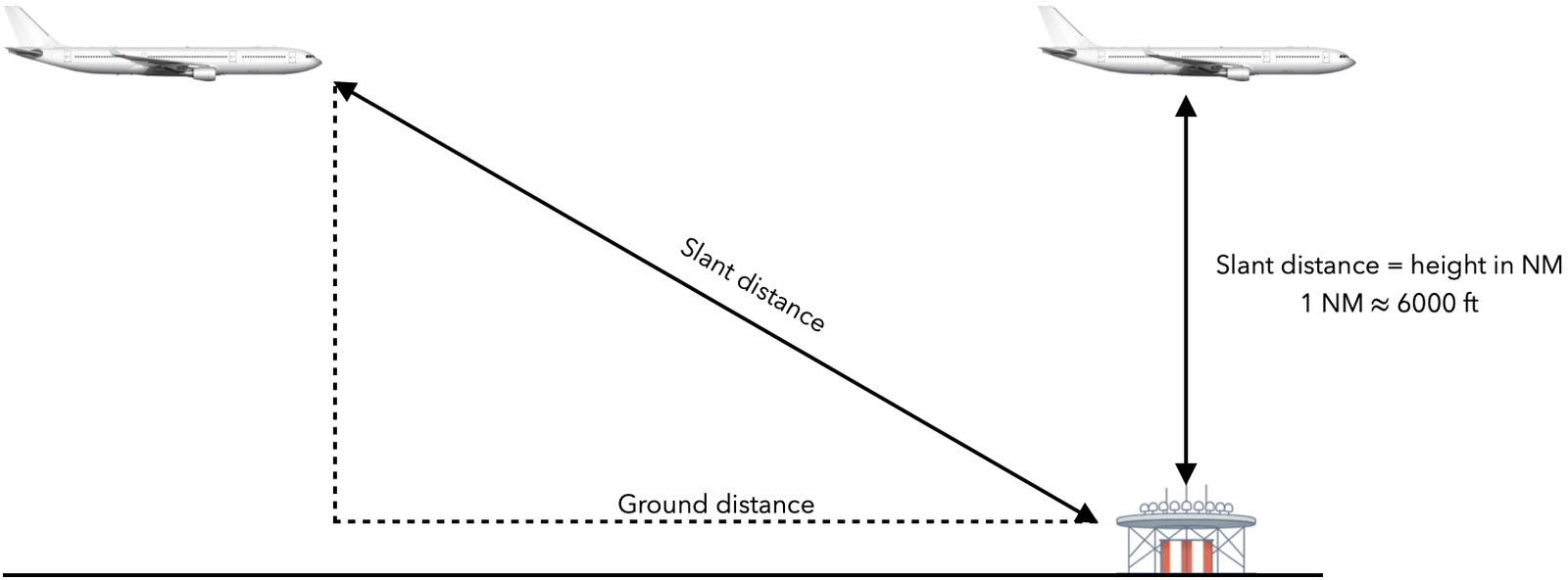
What is the DME slant range error?
DME provides the slant range distance, which is the straight-line distance between the aircraft’s DME receiver and the ground-based DME transmitter. This is not the same as the horizontal ground distance.
The slant range error becomes most significant when the aircraft is directly overhead the DME station. In that case, the DME reading corresponds approximately to the aircraft’s altitude in nautical miles (e.g. at 6,000 ft, it shows about 1 NM; at 30,000 ft, about 5 NM).
As the aircraft moves farther from the DME station, the slant range error diminishes and becomes practically negligible.
How does the Instrument Landing System (ILS) work?
The ILS (Instrument Landing System) provides precision lateral and vertical guidance to aircraft on final approach using two ground-based components:
- The localizer for lateral (horizontal) guidance
- The glideslope for vertical guidance
Each component transmits two modulated signals at different frequencies: 90 Hz and 150 Hz.
The aircraft’s ILS receiver compares the strength of these signals to determine the aircraft’s position relative to the approach path.
Localizer (centerline guidance):
- If the receiver detects more 90 Hz than 150 Hz, the aircraft is left of the centerline
- If the receiver detects more 150 Hz than 90 Hz, the aircraft is right of the centerline
- If both signals are equal, the aircraft is on the centerline
Glideslope (vertical path):
- If the receiver detects more 90 Hz than 150 Hz, the aircraft is above the glide path
- If the receiver detects more 150 Hz than 90 Hz, the aircraft is below the glide path
- If both signals are equal, the aircraft is on the glide path
This system enables precise approaches in both visual and low-visibility conditions.
Cruise
6.25€/month
- Access to selected Q&A
- All technical questions
- All non-technical questions
- All type-specific questions
- Access exclusive articles
- No automatic renewal
- Access for 12 months
Climb
8.75€/month
- Access to selected Q&A
- All technical questions
- All non-technical questions
- All type-specific questions
- –
- No automatic renewal
- Access for 8 months
Take-off
15€/month
- Access to selected Q&A
- All technical questions
- All non-technical questions
- –
- –
- No automatic renewal
- Access for 4 months
Taxi
20€/month
- Access to selected Q&A
- All technical questions
- All non-technical questions
- –
- –
- No automatic renewal
- Access for 1 month